Aechelon Technology, long known in defence circles for its geospatial simulation and Synthetic Reality training systems, has launched Project Orbion in collaboration with Niantic Spatial, ICEYE, BlackSky, and Distance Technologies. The goal, in short, is to construct a live, AI-enabled digital twin of the Earth.
Defense and security decision-making increasingly depends on real-time, multi-sensor data. Project Orbion fuses satellite imagery, radar intelligence, photogrammetry, and AI into a continuously updated 3D model of the planet. Unlike traditional simulators, this system is designed to keep pace with the world as it changes. Wildfires, floods, military movements, shipping lanes, disaster response—all can be tracked and modeled as they unfold.
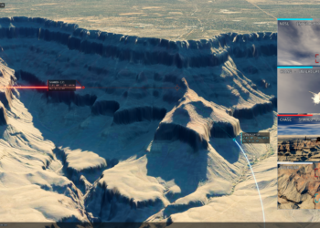
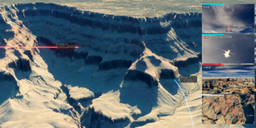
The system can be used in two ways. First, using heads-up displays and other technologies, users can see through objects and terrain. They can also see live video overlays in certain situations that marry on-the-ground situational data, geospatial information, and even prediction data based on vehicle and troop movements. The system can also be used to train AI in real time, allowing it to move through the model of the earth and learn how to interact with terrain, buildings, and water.
It is, in a word, wild.
The advantage is clear. Training AI models on ground-truth environmental data, not just human-generated datasets, promises sharper situational awareness and safer decision-making. For both defense and dual-use civilian applications, Orbion signals a shift from static simulation to living Synthetic Reality.
The tech stack is impressive and required the work of a number of companies to pull off. Niantic Spatial contributed its large geospatial model reconstruction and visualization, including its Visual Positioning System for GPS-denied environments. Finland’s ICEYE brought synthetic aperture radar data that allows persistent observation through clouds, darkness, or smoke. Seattle’s BlackSky added high-cadence Earth observation imagery and real-time analytics, while Helsinki’s Distance Technologies integrated 3D light field displays and AR HUDs to place battlefield intelligence directly into an operator’s view. Aechelon ties these capabilities together through its Skybeam platform, creating a global baseline for simulation and AI training.
Project Orbion extends beyond technical novelty. For militaries, it offers a training and operations environment that mirrors the real world under real conditions. For emergency services, it means faster and safer deployment in crisis zones where GPS and communications infrastructure may be compromised.
The ambition is to create what Aechelon calls the “operating system for human-AI interaction.” That phrase captures both the promise and the risk: this is not just another visualization tool, but potentially a backbone for how machines and humans perceive and act upon the world together.